Did you know?
The town of Radcliffe appears in the Domesday Book, created by the Norman king William the Conqueror, as Radeclive.
Linking Manchester with Lancashire Through Ringley Road Station
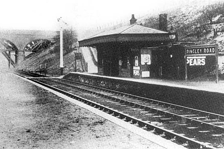
Outwood Country Park was an important transportation link between Manchester and the Lancashire towns of Accrington and Bacup, and the park still maintains strong links with Bacup through the Irwell Sculpture Trail. In 1847, Ringley Road Station was opened by the East Lancashire Railway.
It was by no means a grand station; Ringley Road consisted of simple platforms on either side of the tracks. A small building, which may once have been a ticket office or waiting room, sat on the northbound platform, while no buildings existed up the southbound line. The southbound platform has since disappeared, either through demolition or gradual erosion, but the northbound is still visible and gives an idea of what the past looked like.
Travellers to and from Lancashire will have experienced a journey across Outwood’s stunning viaduct. The Grade II listed viaduct on the north side of the park spans 340ft across and 70ft above the River Irwell, allowing trains to connect Clifton Junction with Bury and beyond. Built in 1846, the viaduct was constructed by contractors working for the Manchester, Bury and Rossendale Railway. The original arches were made from timber but were replaced in 1881 with the cast iron arches that are still present today. The timber decking was replaced in 1923 before the railway was closed to trains in 1966.

The viaduct underwent reconstruction work and was reopened to the public as a foot and cycle path in June 1999. The position of the viaduct and the steep embankments to either side means the only safe viewing is from the deck itself. Hikers on the Outwood Trail walking through the trees will be treated to some incredible scenery that includes the river and Radcliffe beyond, as the viaduct comes into view in dramatic style.
Did you know?
Outwood was known for its Trencherbone coal, which was reputedly the best coal to be produced in the North West
The Mining Past of Outwood
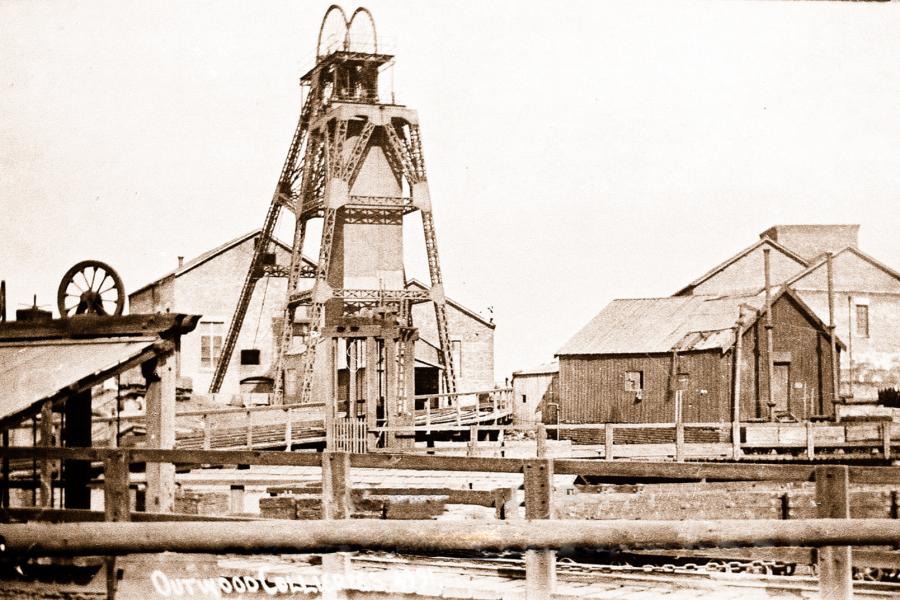
The towns around Manchester were well-known for coal mining and were part of the Manchester Coalfield. Outwood Colliery was part of the Irwell Valley Fault, an area that was extensively mined for almost 100 years. Outwood was opened in 1840, although there is evidence that the mine was sunk almost ten years prior. Initially known as Clough Fold, the original mine had five shafts, however, upon its closure, it was noted that only three remained active. Coal was mined in two pits and transported by tram to two locations. The first was to a depot on Outwood Road, north of the country park and the second was also by tram, where it was loaded onto barges to travel along the now disused Manchester, Bolton and Bury canal.
The colliery exchanged hands a number of times over its lifespan. Thomas Fletcher and Sons, who owned a number of mines in the area, owned Outwood until insolvency took the company in 1908. In 1909, the site was put up for auction, but the reserve price was not met and there were growing concerns for its future. Clifton and Kearsley Coal Co privately bought the mine and their subsidiary company, Outwood Collieries Ltd, managed and operated the site. The new owners made substantial improvements and the mine continued to operate and at its height, the colliery employed around 2,000 staff.
In 1929, Outwood became part of Manchester Collieries Ltd, but production of coal had already begun to wind down. A huge underground fire in 1930 further led to the colliery’s demise. The fire caused one of the shafts to collapse, resulting in the headgear falling into the shaft, while the winding rope destroyed the engine house. A year later, Outwood Colliery was closed but continued to operate as a coal washing point for coal from other collieries. This continued until 1956 when operations at Outwood finally came to an end.
Visiting Outwood Country Park
Outwood Country park can be accessed by three locations. Two are situated at Ringley Road to the south and James Street North. Metrolink is available at the Radcliffe stop, which is a 15-minute walk away from the park, or Whitefield, which is a little further afield with a 35-minute walk. Limited parking is available at James St North and the park links with the national cycle network. The third entrance at St. Aidan’s Close to the south is only accessible for hikers, due to its location in the main residential area of Outwood.
If you’re looking to visit one of the most beautiful parks in Manchester that comes with some added history, Outwood Country Park is waiting to be explored.